
Rethinking Stormwater From Waste to Urban Resource
For more than a century, urban drainage has been organized around a simple premise: rain is a problem to remove as quickly as possible. Streets, roofs, parking lots, and sidewalks shed water onto inlets, which feed a network of underground concrete pipes designed to move runoff toward a river, harbor, or treatment facility. That approach can protect a site during ordinary storms, but it also treats every drop as hazardous waste rather than as a resource that can replenish soils, support vegetation, and reduce pressure on downstream infrastructure.
That assumption is becoming increasingly expensive. Denser development adds impervious surface while aging culverts and outfalls face increasingly intense cloudbursts. When a storm exceeds the design capacity of a centralized network, water has few places to go. It rises onto streets, enters buildings, disrupts transit, contaminates waterways, and threatens residents in low-lying neighborhoods. As catastrophic precipitation events increase across urban centers, municipalities are discovering that nature-based hybrid solutions provide resilient flood risk reduction. Sponge city planning offers a different operating model: capture, slow, filter, store, and infiltrate precipitation close to where it lands.
The Costly Limits of Traditional Subsurface Gray Pipes
Gray infrastructure remains essential. Pipes, culverts, pumps, detention vaults, and flood barriers provide predictable conveyance and are often the only practical protection in highly constrained locations. The problem arises when a city relies on conveyance alone. A pipe that rapidly removes water from one block can send a sharper surge into the next part of the watershed. High runoff velocity can erode streambanks, carry sediment and pollutants, and overwhelm centralized discharge points. During extreme rainfall, widening one segment may simply transfer risk to another.
The financial burden is equally significant. Underground assets are difficult to inspect, costly to excavate, and disruptive to replace beneath active roads. Municipalities must fund emergency repairs, pump stations, inlet cleaning, structural assessments, and periodic capacity upgrades, often while competing with transportation, housing, and public health priorities. A nature-based approach does not eliminate these obligations, but it can reduce the volume and speed of water entering the network. The Nature Conservancy describes floodplain restoration, wetland protection, and other nature-based measures as tools that can reduce damages while producing benefits for water quality, habitat, recreation, and local economies.
Rigid drainage also creates less visible environmental costs. Impervious surfaces absorb solar heat, contributing to urban heat islands, while preventing rainfall from reaching groundwater and urban soils. Vegetation suffers from compacted, dry planting beds even as streets flood during storms. A distributed system addresses these linked problems by using soil, roots, gravel, wetlands, and surface storage as active components of the drainage network.
- Hydraulic risk: rapid conveyance concentrates peak flows at downstream outlets.
- Budget exposure: buried assets require expensive excavation, inspection, repair, and replacement.
- Water quality impacts: untreated runoff can carry oil, metals, sediment, nutrients, and litter into receiving waters.
- Urban climate impacts: hard surfaces intensify heat and reduce natural groundwater recharge.
- Community vulnerability: neighborhoods with limited elevation, aging buildings, or inadequate drainage often experience repeated losses first.
Engineering Resilience Across the Street Grid
The practical distinction between conventional drainage and a sponge city is not a choice between engineering and nature. It is a choice between concentrating hydraulic functions in a few large assets and distributing them across many smaller assets. Conventional conduits remain valuable for overflow, public safety, and areas where infiltration is unsuitable. Bioswales, permeable surfaces, tree pits, wetlands, and detention areas reduce the burden placed on those conduits before water reaches them.
| Planning factor | Conventional subsurface system | Distributed sponge alternative |
|---|---|---|
| Peak flow control | Conveys water quickly, with limited local storage | Slows, stores, infiltrates, and evapotranspires water across multiple sites |
| Land requirement | Uses limited surface space but requires extensive underground corridors | Needs visible space in rights-of-way, parks, sidewalks, and private parcels |
| Initial civil outlay | High excavation, utility coordination, and construction costs | Variable costs, often lower for targeted retrofits but dependent on soil and site conditions |
| Maintenance profile | Specialized inspection, cleaning, structural repair, and emergency access | Routine vegetation care, sediment removal, surface cleaning, and periodic soil or inlet rehabilitation |
| Additional public value | Primarily drainage capacity | Shade, habitat, public space, traffic calming, cooler surfaces, and improved water quality |
Distributed retention does not mean that every site must absorb all rainfall. The design objective is to shave the peak from the hydrograph, retain an appropriate first flush, and delay remaining flows until downstream systems have capacity. Even modest interventions can matter when repeated across an entire catchment. A series of curb extensions, for example, can intercept runoff from adjacent pavement, while permeable parking bays can hold water in a stone subbase and release it slowly.
Core Elements of Street-Level Sponge Infrastructure
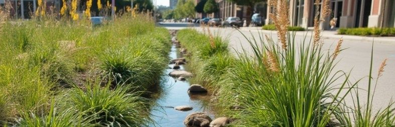
Bioswales are among the most adaptable tools for retrofit projects. These planted channels use engineered soil, vegetation, aggregate, and underdrains to reduce flow velocity and trap sediment. Properly designed soil media can support infiltration while filtering certain pollutants, including hydrocarbons associated with vehicle traffic. In dense corridors, bioswales can fit into curb extensions, medians, parking lanes, or the edges of public facilities. Their performance depends on careful grading, adequate pretreatment, safe overflow routes, and plant selections suited to both drought and periodic inundation.
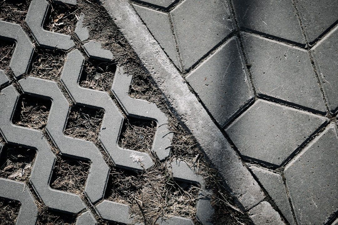
Permeable interlocking concrete pavers and porous asphalt extend the same principle across walking, parking, and low-speed vehicle areas. Instead of directing all rain toward a curb inlet, the surface allows water to pass into a crushed-stone reservoir below. That subbase can temporarily store runoff, permit infiltration into suitable soils, or connect to a controlled underdrain. These materials are not universal substitutes for conventional pavement. Fine sediment can clog them, freeze-thaw conditions can affect performance, and heavy truck routes require specialized structural design. Regular sweeping and inspection are therefore part of the lifecycle plan, not optional cosmetic work.
At a larger scale, retention wetlands and daylighted ponds provide storage during cloudbursts while creating habitat and public amenities. A former drainage channel can become a visible water corridor with walking paths, shade trees, and carefully designed flood zones. Wetlands can also improve water quality by slowing flows and allowing suspended material to settle. Safety, mosquito control, water-level fluctuation, and long-term land stewardship must be addressed, but these spaces can deliver far more value than a fenced concrete basin that is used only during rare storms.
- Bioswales: planted conveyance features that slow runoff, filter pollutants, and support infiltration.
- Permeable paving: surfaces that transfer water into a storage layer beneath sidewalks, plazas, or parking areas.
- Tree trenches: connected soil volumes that give roots room to grow while storing and treating runoff.
- Wetlands and ponds: larger detention and treatment landscapes that buffer peak flows and support public use.
- Green roofs and cisterns: building-scale measures that reduce the volume reaching streets during smaller and moderate storms.
How Municipalities Implement Nature-Based Retrofits
Successful implementation begins with a catchment audit rather than a single showcase project. Public works teams can map flood complaints, basement backups, undersized inlets, steep flow paths, vacant parcels, tree canopy gaps, and underused rights-of-way. Street redesign schedules are especially valuable because drainage improvements can be coordinated with resurfacing, sidewalk reconstruction, transit upgrades, utility work, and traffic safety projects. This approach reduces repeated excavation and helps align stormwater spending with other capital programs.
Hybrid design is essential in built-out districts. A bioswale may capture routine runoff while a perforated underdrain sends excess water to a legacy pipe. A wetland may detain the first part of a cloudburst while an overflow vault protects adjacent homes during larger events. Engineers should model soil infiltration, groundwater conditions, pollutant loading, maintenance access, utility conflicts, and failure pathways. The aim is not to remove every pipe, but to make the overall network less dependent on any single asset.
- Identify priority catchments: combine flood records, topography, asset condition, social vulnerability, and planned public works projects.
- Assess site suitability: test soils, locate utilities, review groundwater levels, and determine where infiltration, detention, or lined systems are appropriate.
- Design a treatment train: connect roofs, curb inlets, bioswales, permeable surfaces, storage areas, and controlled overflow routes.
- Launch pilot zones: select representative blocks where performance can be measured through gauges, inspections, maintenance logs, and resident feedback.
- Scale what works: update design standards, procurement specifications, maintenance budgets, and capital plans using lessons from the pilot.
Pilot projects should be evaluated as infrastructure, not merely as beautification. Useful measures include peak flow reduction, storage volume, infiltration time, pollutant removal, maintenance hours, pavement condition, tree survival, and avoided flood claims. Equity indicators matter as well. A project that protects a high-value commercial district but leaves flood-prone residential blocks exposed is not a complete resilience strategy. Community boards and neighborhood organizations can help identify access concerns, preferred public-space functions, and locations where construction disruption must be carefully managed.
Building Climate-Ready Neighborhoods From Block to Borough
Vegetative hydrology changes the role of civil infrastructure. Instead of depending on a few brittle channels to move water away at maximum speed, a city can create layers of adaptive capacity across streets, buildings, parks, and waterways. Pipes remain part of that system, but they operate with more reserve capacity. Soil, roots, wetlands, and surface storage become working assets that reduce pressure before a storm reaches the most expensive components.
The strongest roadmap is practical: map risk, prioritize vulnerable communities, coordinate projects with scheduled street work, fund maintenance from the beginning, and measure results after every installation. Municipal planners can invite community boards to champion block-level opportunities, while public works directors can translate successful pilots into repeatable standards. Small shifts, city-scale results, can protect balance sheets and residents alike. From block to borough, the goal is a drainage network that treats rain as something to manage intelligently, not waste as quickly as possible.